NASA studies March 3 severe weather outbreak with infrared, microwave vision

A NASA satellite used infrared and microwave "vision" to analyze the storm system that created the March 3 severe weather outbreak in the U.S.
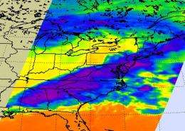
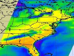
On March 3, 2012, the Atmospheric Infrared Sounder (AIRS) instrument flies aboard NASA's Aqua satellite captured infrared and microwave data of the front that generated the severe weather during the early morning and early afternoon hours.

On the Aqua satellite's first overpass on March 3, infrared data from AIRS showed the strong low pressure area centered on the Great Lake that powered a cold front into the U.S. South and ahead of the front lay an incursion of unusually warm moist air. Where the two met, a line of severe thunderstorms developed which spawned the killer tornadoes and damaging straight line wind storms. "The infrared imagery for the (first) descending pass shows the very cold cloud tops stretching from Alabama to beyond the coastline of Massachusetts," said Ed Olsen of the AIRS Team at NASA's Jet Propulsion Laboratory, Pasadena, Calif., who creates the images with AIRS data. Cloud top temperatures were as cold as -70 Celsius (-94 Fahrenheit) in some of the storms, which indicated powerful thunderstorms with very high cloud tops.
"The AIRS microwave imagery indicates heaviest precipitation in a band stretching across Alabama and Georgia," Olsen said.

The National Oceanic and Atmospheric Administration's Storm Prediction Center (SPC) report map for March 3, 2012 indicated 12 reports of tornadoes, 34 reports of high winds, and 2 reports of hail from southern South Carolina, to southern Georgia, and northern and central Florida. Tornado reports in Georgia came from the towns of Colquitt, Meigs, Hansell, Pelham, Branchville, two tornadoes reported near Moody Air Force Base and two near Vada. In Florida, tornadoes were reported in Branchville and Wetumpka. For a detailed report from the SPC, visit: .
The day before, the Storm Prediction Center (SPC) reported 144 tornadoes, 307 high wind reports, and 464 reports of hail in Alabama, Tennessee, Indiana, North Carolina, South Carolina, Kentucky, Mississippi, West Virginia, Virginia and Ohio. For a detailed report from the SPC, visit: .
When NASA's Aqua satellite made an afternoon orbit over the southeastern U.S. on March 3, infrared imagery showed the severe weather band at the coastline, with a strong storm system over southern Georgia. The microwave imagery showed strong convection and rain over southern Georgia.
Provided by JPL/NASA


