New weather satellite delivers for WA forecasters

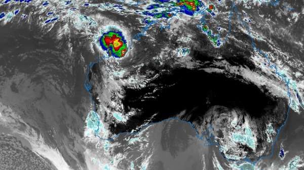
Six months into its operation, besides producing some , Japan's newest weather satellite Himawari-8 has significantly improved WA's everyday weather forecasting.
"Where Himawari really helps is its rapid updates. We're able to see the short term development of things like thunderstorms," Perth-based Bureau of Meteorology expert Neil Bennett says.
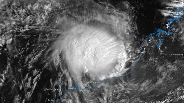
"The fact that we've got the resolution to see as small as half a kilometre, compared to the four kilometres we were getting from the old satellite, also means that we're looking at things in far more detail.
"It has really delivered, and we've seen some quite remarkable imagery."
While many weather satellites pass overhead only periodically, Himawari-8's geostationary orbit puts it permanently 35,000 km above Australia and Japan.
This allows the satellite to produce an image of the entire hemisphere every 10 minutes.
It takes just 20 minutes for that image to make its way to Perth from space, via Japan and the bureau's head office in Melbourne.
"Something that has been really exciting for forecasters is to be able to see the movements of tropical cyclones," he says.
It's been a relatively quiet cyclone season so far, but it came into its own with Tropical Cyclone Stan," Mr Bennett says.

Stan, the first cyclone of this season, crossed the coastline near Port Hedland on January 31st.
The satellite has also "been a real game changer" in helping to track recent bushfires in WA's south-west, Mr Bennett says.
Compared with a regular camera three sensor's (red, green and blue), Himawari detects 16 different light wavelengths.
This capability means Himawari can see water vapour, infra-red emissions and atmospheric particles based on how they reflect or emit that light, allowing it to detect where fires are starting and smoke plumes are developing.
The bureau supplies that data to Landgate and the Department of Fire and Emergency Services to enable real-time fire tracking during emergencies and improve understanding of how bushfires start.
The data also allowed meteorologists to study an unusual phenomenon: a storm cloud called a pyrocumulonimbus forming inside the fire itself.
Described by Mr Bennett as "spectacular and scary at the same time", the cloud is created by hot updrafts from the fire rising into the atmosphere.
While these clouds occasionally produce rain, they more often bring lightning strikes, which risk starting further fires.
More information: The Bureau makes satellite data available to the public through its website:
Provided by Science Network WA
This article first appeared on a science news website based at Scitech.


