NASA casts an infrared eye on Tropical Storm Irwin

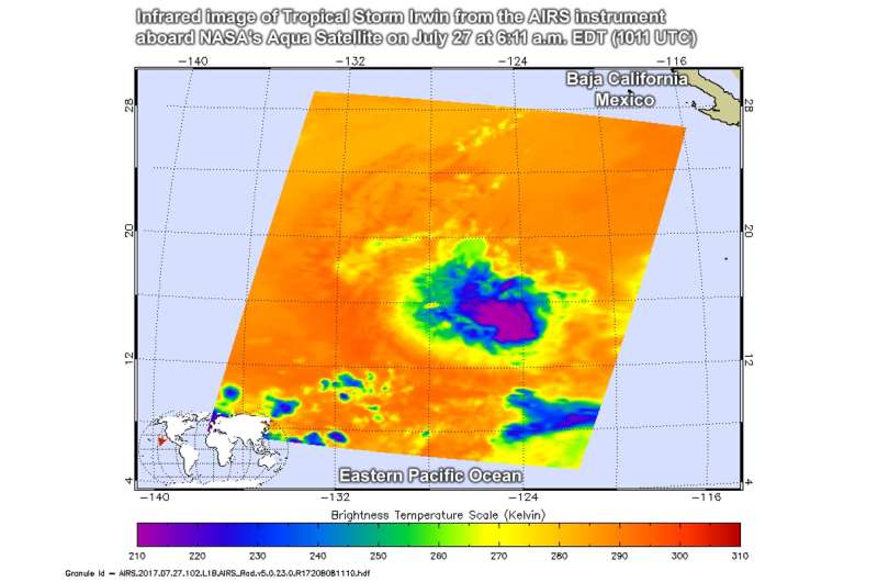
Infrared imagery from NASA looked at cloud top temperatures in Tropical Storm Irwin and found the strongest storms in the system were west of its low-level center.
The Atmospheric Infrared Sounder or AIRS instrument aboard NASA's Aqua satellite looked at Tropical Storm Irwin in the Eastern Pacific Ocean in infrared light. Infrared light provides data on temperatures. The higher the cloud tops, the colder and the stronger they are. So, infrared light as that gathered by the AIRS instrument can identify the strongest sides of a tropical cyclone. Of course, infrared data can also tell if temperatures have warmed, meaning that the uplift has weakened in the system. Weaker uplift means less creation of the thunderstorms that make up a tropical cyclone.
The AIRS data were taken on 6:11 a.m. EDT (10:11 UTC) on July 27 and showed strongest storms were west of the center. Cloud top temperatures west of center were as cold as minus 63 degrees Fahrenheit (minus 53 degrees Celsius). NASA research has shown the storms with cloud tops that cold have the potential to generate heavy rainfall. The infrared data was false-colored at NASA's Jet Propulsion Laboratory in Pasadena, California, where AIRS data is managed.
National Hurricane Center forecaster Lixion Avila noted that the low-level center appears to be located on the eastern edge of the deep convection due to the shear caused by Hilary's outflow.
At 11 a.m. EDT (1500 UTC) on July 27 the center of Tropical Storm Irwin was located near 15.0 degrees north latitude and 124.2 degrees west longitude. That's about 1,080 miles (1,740 km) west-southwest of the southern tip of Baja California, Mexico. Irwin was moving toward the west near 2 mph (4 kph), and little motion is anticipated during the next day or two. The estimated minimum central pressure is 1000 millibars. Maximum sustained winds are near 60 mph (95 kph) with higher gusts. Little change in strength is forecast during the next 48 hours.
NHC said that two of the models show that Irwin will likely be absorbed by nearby Hurricane Hilary within 5 days.
Provided by NASA's Goddard Space Flight Center


