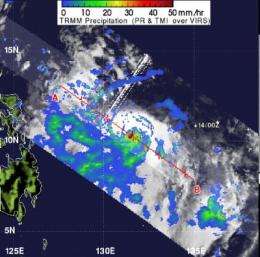
NASA sees heavy rainfall around compact Typhoon Guchol's center

Typhoon Guchol has spawned alerts in the Philippines as it is forecast to skirt the eastern part of Luzon this weekend, and will likely spawn warnings in Okinawa and western Japan over the next couple of days as it tracks in that direction. NASA's TRMM satellite analyzed rainfall within the storm and found heavy rainfall around the center of circulation, falling at a rate of over 2 inches/50 mm per hour and there were hot towering thunderstorms.
The Philippine Atmospheric, Geophysical and Astronomical Services Administration (PAGASA) have issued a Typhoon Warning for shipping interests today, June 15, 2012. That warning can be found at: . For more updates from PAGASA, visit: .
The Tropical Rainfall Measuring Mission satellite called TRMM measures how much rain can fall per hour in storms. On June 15, TRMM analyzed the rainfall rate within Typhoon Guchol, also known in the Philippines as "Typhoon Butchoy." A rainfall analysis was made at NASA's Goddard Space Flight Center in Greenbelt, Md. that used data from TRMM's Microwave Imager (TMI) and Precipitation Radar (PR) instruments. That analysis was overlaid on an enhanced infrared image from TRMM's Visible and InfraRed Scanner (VIRS) instrument and showed heavy convective storms were dropping intense rainfall of over 50mm/hr (~2 inches) around the storm's center. The areas of that heavy rainfall were occurring from "Hot Towers," or towering thunderstorms. TRMM Precipitation Radar showed those hot towers were higher than 15km (~9.3 miles). The coldest cloud top temperatures were near -74 Celsius (-101 Fahrenheit)!
On June 15, 2012 at 1200 UTC (8 a.m. EDT) Guchol's (Butchoy) maximum sustained winds were near 90 knots (103.6 mph/166.7 kph). The strong winds were creating very rough seas and high waves in the Philippine Sea, where wave heights were near 33 feet (10.6 meters). Guchol was about 660 miles east-southeast of Manila, Philippines, near 11.6 North and 130.6 East. It was moving to the northwest at 7 knots (8 mph/13 kph).
Guchol is still a small system, very compact and strong. Satellite imagery enabled forecasters to estimate that it is about 110 nautical miles in diameter. The eye is currently cloud-filled on satellite imagery.
Forecasters at the Joint Typhoon Warning Center expect Guchol to continue intensifying as it tracks toward Okinawa and then re-curve toward western Japan over the next several days. Residents along the path of the storm should prepare for very rough surf, heavy rainfall and typhoon conditions over the weekend.
Provided by NASA's Goddard Space Flight Center


